The Shape of Valleys
Flat Bottoms
The bottom of a valley can be fairly flat for one or both of a couple of reasons:- The valley may be partly filled with material from upstream, often much of it deposited by glacier melt water. There may a great deal of gold on the bedrock, but there may also be dozens or even hundreds of feet of clay, sand, gravel, etc. between the stream bed and that bedrock.
- In a valley that is already fairly flat and the angle downstream is low, the stream may meander back and forth across the valley. Streams tend to erode most on the outside of bends and deposit material on the insides of bends - over time, the stream moves sideways. The bottom of the valley can continue to be flat, even as erosion makes it deeper.
Erosion can leave benches at different heights above the creek, scattered around and along a more or less flat bottomed valley. Gold deposited by the stream in one place may be way off to the side of the current location of the stream.
U and V Shaped Valley Bottoms
The cross section of a valley - its shape looking up or down stream - can sometimes tell you something about its geological history.A V-shape cross section generally means no glaciers have moved down the valley.
A U-shaped cross section in a large enough valley can be the result of it being reamed out by a glacier. This will generally remove benches on the valley wall up to how high the ice was.
If You Have Had Enough Geology...
The rest of this page is provided
mostly for its interest value
Meandering Streams
A meandering stream is one that winds back and forth on a relatively flat valley bottom, generally where the angle down the valley is moderate.Moving water has momentum like a moving car - it tends to keep moving in the same direction. Where a stream bends, the fastest part of the stream goes to the outside of the bend. Streams often erode their banks in these places - part way around a bend on the outside.
Around the bend on the inside, the water slows down and (some of the) material that is being moved by the stream is deposited. This is one of the most important places to check a stream for gold.
Because bends can cause erosion on one side of the stream and deposits on the other, the stream channel can slowly change the shape of the bend and move the stream sideways. Over long periods, a meandering stream can flow over most or all of a valley bottom, even though the stream channel is relatively small at any one time.
If a loop develops in a meandering stream, during high water part of the stream may take a short-cut. In some cases, the short-cut can become the channel by erosion - sometimes a massive amount of erosion in a matter of days or even hours. Thus the village of Kaskaskia, Illinois now lies on the West side of the Mississippi, despite the fact that the river has always defined the Western border of Illinois.
Ice Ages
There have been a number of ice ages in the past few million years, with cooling and warming periods in which glaciers and ice sheets advance and retreat. Ice sheets can be 3 or 4 kilometers thick. (Actually, a geologist would say that we are now in a warming period of an ice age that began about 2.5 million years ago.)Valley (Alpine) Glaciers
Valley Glaciers form when great amounts of snow fall in the the high-elevation, upstream end of a valley, and the weight of the snow turns it into ice. If this process continues, the lower end of the glacier slowly flows down the valley.When these glaciers advance, they ream out valleys and move rock and gold around.
Ice Sheets Over Parts of BC
During ice ages, parts of BC (including the Cariboo) were covered by ice sheets that were relatively static - they moved in and just sat there. This prevented valley glaciers from reaming out valleys in some areas.Glacial Melt-Water
When glaciers and ice sheets melt, tremendous amounts of water REALLY move rock and gold around. This can create or enlarge valleys in some places, and partially fill valleys with clay, sand, boulders, etc. in other places.The extremely rich deposits in Williams Creek in Barkerville in the Cariboo area were found 80 feet below the level of the creek. The depth to bedrock under Lightning Creek in the Cariboo is 200 feet in some places.
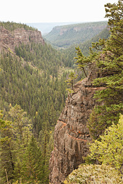
The photo at the top right of this page shows a "Chasm Created by Glacial Runoff near Clinton, British Columbia" (the photo caption by Getty Images).
Glacial Till
 Glacial Till is material that has been deposited directly by
glaciers. It rarely contains placer gold worth mining.
In a valley that was reamed out by a glacier, till is the material that was moved. It is usually a random mixture of clay, silt, sand, gravel and boulders. In some cases, the clay in till is a greyish or bluish color. The gravel and larger pieces are usually angular rather than rounded.
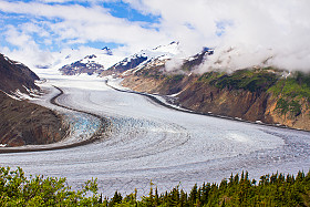
In the photo of Salmon glacier (according to the caption by Getty Images), you can see material along the sides that the glacier has picked up as it moved down the valley.
Good Knowledge of Geology Not Required
Being able to identify rocks and minerals is occasionally useful for placer miners. For example:In the Cariboo, most of the richest deposits around Barkerville - reached by underground mining deep under streams - were found on or near the top of blue clay (which at least one old geologist referred to as "rotten blue shale").
Generally, however, this kind of knowledge of geology is not particularly useful for placer miners (although it is very important for hard rock prospecting).
So...
Placer gold really is "where you find it".
Notices
Copyright 2011 to 2024 by Brian MarshallCopyright 2024 by The Omineca Mining Association
All images on this website are copyrighted by their owners and they may not be downloaded for other than personal use - republication, retransmission, reproduction or other use is prohibited.
Note: This page may contain images from FREEBigPictures.com.
INFORMATION PROVIDED BY THIS WEBSITE IS PROVIDED "AS IS", WITHOUT WARRANTY OF ANY KIND, EXPRESS OR IMPLIED, INCLUDING BUT NOT LIMITED TO THE WARRANTIES OF ACCURACY, MERCHANTABILITY, FITNESS FOR A PARTICULAR PURPOSE AND NON-INFRINGEMENT. USE AT YOUR OWN RISK.
 Knowing a little geology is relevant to placer mining and
prospecting
for gold in BC. Knowing a lot more about geology doesn't really help
much.
 Streams pick up material and move it downstream. Practically
any stream can pick up and carry fine silt. A faster currents can
pick up sand, pebbles, gravel. Even if a stream can't pick up
heavier pebbles and gravel, enough current will roll them along
the bottom and maybe pick them up briefly. This is why river
gravel is rounded - corners get broken off as pieces bump each
other.